Pfunderer Mountains with ascent to Hochfeiler
Four days through the wild Pfunderer Mountains to the roof of the Zillertal Alps a classic hut trek crowned by the 3,510m Hochfeiler summit.
Tour Details
- Location: italy-zillertalalps-pfunderermountains
- Duration: 4 Days
- Difficulty: challenging
- Price: EUR 400 per person
- Guide: Michel Visser
- Group Size: Up to 8
- Elevation Gain: 1100m
- Distance: 42km
- Terrain: Rocky trails, Alpine meadows, Glacier crossings, Scree slopes, Ridge walks, Mountain passes
- Meeting Point: Bahnhofstraße - Via Stazione 38, 39049 Val di Vizze South Tyrol, Italy
Description
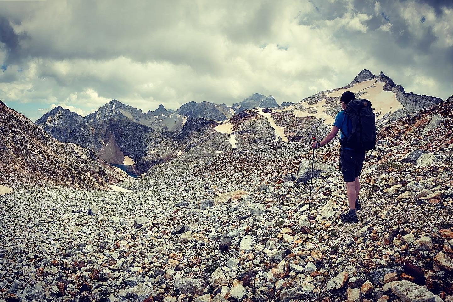
This is one of South Tyrol's great mountain adventures — a four-day traverse through the largely untouched Pfunderer Mountains, finishing with an ascent of the Hochfeiler (3,510m), the highest peak in the Zillertal Alps. It's a tour for hikers who are ready to earn their views. The Pfunderer Mountains offer the Alps at their most solitary and pristine. Most of the high trail runs between 2,000 and 3,000 metres, and there's a real chance you'll spend whole days seeing no one but the hut keepers, marmots, and the occasional ibex. This is not the packaged Alps of ski resorts and tourist villages — it's raw, high terrain that demands respect and rewards it generously. The route connects secluded valleys, lush alpine meadows, idyllic mountain lakes, and panoramic peaks. We move from hut to hut through a landscape shaped by glaciers and centuries of alpine farming, sleeping in proper mountain huts with half-board meals and the particular camaraderie that comes from sharing a dorm with people who've all had the same hard, brilliant day. The four days culminate in something special: the ascent of the Hochfeiler via the southwest ridge, the normal route to the highest summit of the Zillertal Alps. Starting from the Hochfeilerhütte at 2,710m, the route takes around 2.5 hours to the summit, with the last section exposed, on snow and rocky terrain, with extraordinary views over glaciers. This tour is suitable for fit, experienced mountain hikers who are surefooted on steep, rocky terrain and comfortable with exposed ridgelines. Crampons and an ice axe may be required for the summit push depending on conditions — your guide will assess this on the day. Total elevation gain across the four days is approximately 4,600m.
Tour Highlights
- Stunning sunrise views from mountain peaks
- Local mountain cuisine experience
- Small group for personalized experience
- Panoramic mountain vistas
- Hochfeiler Ascent
- Mountain Huts
Itinerary
- Valley to the High Ground -
Start: Pfitsch valley car park (~1,326m) → Simile-Mahd-Alm (~2,100m) Afternoon start from 13:00 | ~3–4 hours hiking | ↑ ~800m
We meet at 13:00 at the trailhead in the Pfitsch valley — Val di Vizze — and head straight into the mountains. The afternoon start suits this stage well: it's a focused climb rather than a full day, giving us time to settle in before the bigger days ahead.
From the valley we gain altitude quickly, moving through forest and pasture above Freienfeld, past the dramatically named Höllenkragen — Hell's Collar — before reaching the Trenser Joch. The terrain opens up here and the views back down the Wipptal already justify the effort.
We continue along the ridge to the Simile-Mahd-Alm, our first night's accommodation — a simple, characterful alpine pasture hut that is well worth booking in advance. Evening at the hut, dinner together, early night. Tomorrow is longer.
- The Wild Lake Stage -
Simile-Mahd-Alm → Brixner Hütte (~2,293m) ~5–6 hours | ↑ ~850m ↓ ~600m | ~9km
The finest day on the Pfunderer Höhenweg for many people. From the Simile-Mahd-Alm we hike uphill to the Sengesjoch pass and on to the Wilder See — the deepest mountain lake in South Tyrol. This high glacial lake, sitting in a bowl of rock and scree at around 2,600m, is one of those places that stops you in your tracks. The stillness, the colour of the water, the surrounding summits — it's a proper mountain moment.
From the Wilder See we have options depending on conditions and group appetite: an ascent to the Wilde Kreuzspitze at 3,132m — the highest peak in the Pfunderer Alps — is possible before descending via the Rauhtaljoch to the Brixner Hütte. This optional summit adds around 2 hours and is recommended for those with strong legs and clear skies.
The Brixner Hütte sits at the head of the Fane valley above Vals — a well-run hut with a reputation for good food and a fantastic panorama over the surrounding ridges. It's a satisfying place to end a day.
- Into the Zillertal Alps -
Brixner Hütte → Hochfeilerhütte (2,710m) ~5–7 hours | ↑ ~1,100m | demanding
Today we leave the Pfunderer Mountains proper and push west into the Zillertal Alps, heading for the hut that will be our base for the summit. This is the most physically demanding day of the tour — a long, high traverse across rough alpine terrain with significant elevation gain.
The route crosses steep meadow slopes and rocky ground, climbing through several passes with big views north to Austria and south over the South Tyrolean valleys. On narrow paths through wild nature and in front of breathtaking panoramas, this is what alpine hiking looks like when it asks something of you.
The Hochfeilerhütte sits at 2,710m in the Val di Vizze and has been welcoming mountaineers since at least the early twentieth century. Arrive, eat well, rest well. The summit is tomorrow.
- The Hochfeiler Summit & Descent -
Hochfeilerhütte (2,710m) → Hochfeiler summit (3,510m) → Valley car park Early start ~05:00–06:00 | ↑ ~800m to summit, then full descent to valley
Early alarm. Headtorches on if needed. We leave the hut before first light to reach the summit in the morning window, before any afternoon weather builds — the mountains dictate the schedule today.
From the hut, the first section heads northwest on a well-marked path, with fixed ropes on the initial steep passage. After this, the route turns northeast up the ridge toward the summit, with multiple paths through the rubble all converging at the top.
The upper section is a 500m climb over 2km on demanding rocky terrain, with the final approach exposed and often snowy — the views over the glaciers from here are extraordinary. The last 50 metres may require crampons if the ridge holds snow; your guide will carry and assess equipment for conditions.
At 3,510m, the Hochfeiler summit cross marks the highest point in the entire Zillertal Alps. On a clear day the panorama stretches from the Dolomites to the main Alpine ridge and deep into Austria. Take it in — you've earned it.
Descent follows the ascent route back to the hut, then continues down through the Pfitsch valley to the car park. The total descent from summit to valley is around 1,800m — sustained, on good path, with the satisfaction of the whole four days behind you.
What's Included
- Expert certified guide
- Safety equipment
- Specified Meals
- Mountain Huts
Not Included
- Transportation to/from starting point
- Personal hiking equipment
- Travel insurance
- Meals not specified
Why Book With Made to Hike
This tour is led by a certified mountain guide verified through Made to Hike. All guides on the platform hold recognised certifications such as IFMGA, IML, or equivalent local qualifications. Bookings include secure payment processing, a money-back guarantee, and direct communication with your guide before the trip.